

Before continuing, we must clarify several concepts about SINAC, MINAE and conservation areas.
MINAE is the Ministry of Environment and Energy of Costa Rica, which is in charge of administering the money destined to the protection of the environment, it is formed by several institutions:
- SINAC – Sistema Nacional de Áreas de Conservación
- DGGM – Dirección de Geología y Minas
- SETENA – Secretaría Técnica Nacional Ambiental
- TAA – Tribunal Ambiental Administrativo
- OCIC – Oficina Costarricense de Implementación Conjunta
- DTCC – Dirección de Transporte y Comercialización de Combustibles
- FONAFIFO – Fondo Nacional de Financiamiento Forestal
- DGH – Dirección General de Hidrocarburos
- IMN – Instituto Meteorológico Nacional
- CONAGEBIO – Comisión Nacional para la Gestión de la Biodiversidad
- PMP – Parque Marino del Pacífico
The one that interests us here is the SINAC or National System of Conservation Areas, this dependency or organ of the MINAE is in charge of the actual administration of the conservation areas. SINAC has divided the entire country into 11 conservation areas. Within the conservation areas, we find national parks and refuges and protected areas 2:
- Arenal Huetar Norte Conservation Area (ACAHN)
- Arenal Tempisque Conservation Area (ACAT)
- Central Volcanic Mountain Range Conservation Area (ACCVC)
- Guanacaste Conservation Area (ACG)
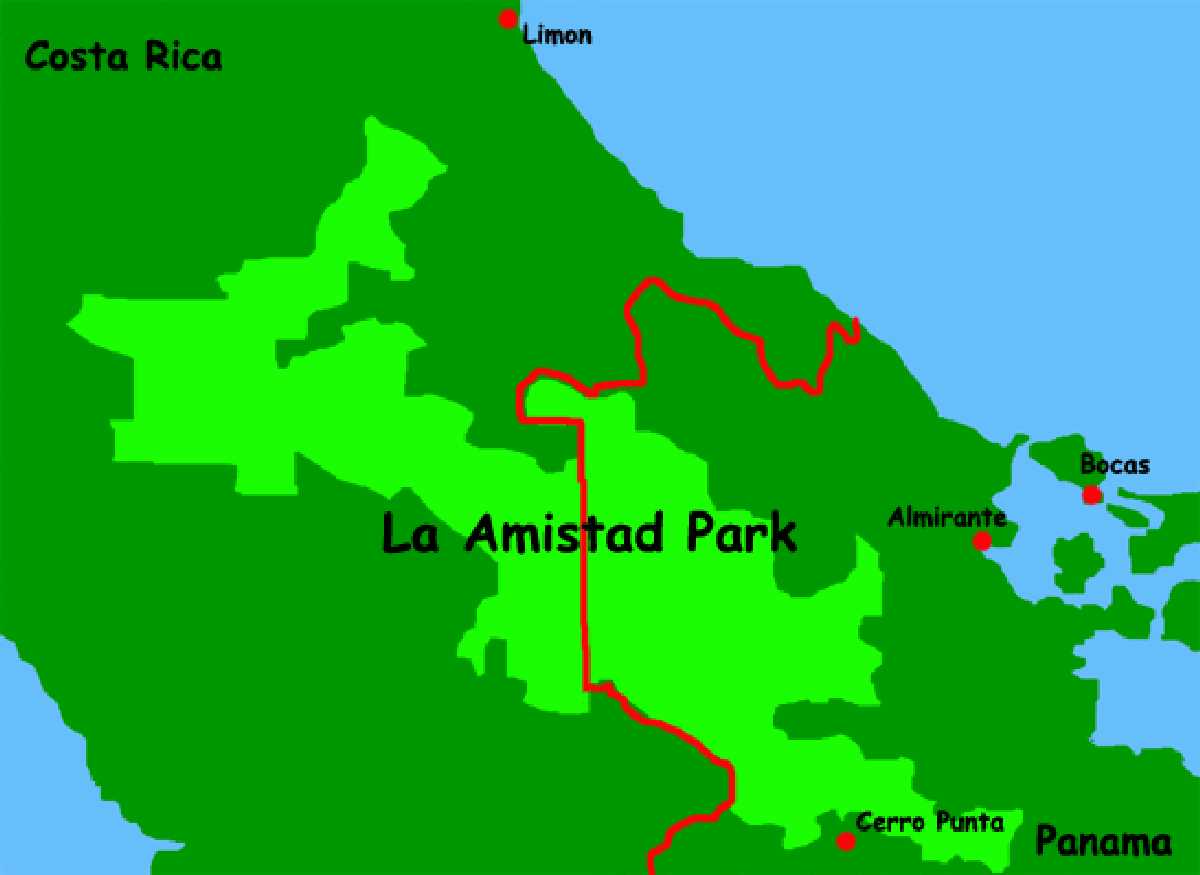
- La Amistad Caribbean Conservation Area (ACLAC)
- La Amistad-Pacific Conservation Area (ACLAP)
- Cocos Island Marine Conservation Area (ACMIC)
- Osa Conservation Area (ACOSA)
- Central Pacific Conservation Area (ACOPAC)
- Tempisque Conservation Area (ACT)
- Tortuguero Conservation Area (ACTo)
What interests us here is the La Amistad-Pacific Conservation Area either ACLAP by its acronym.
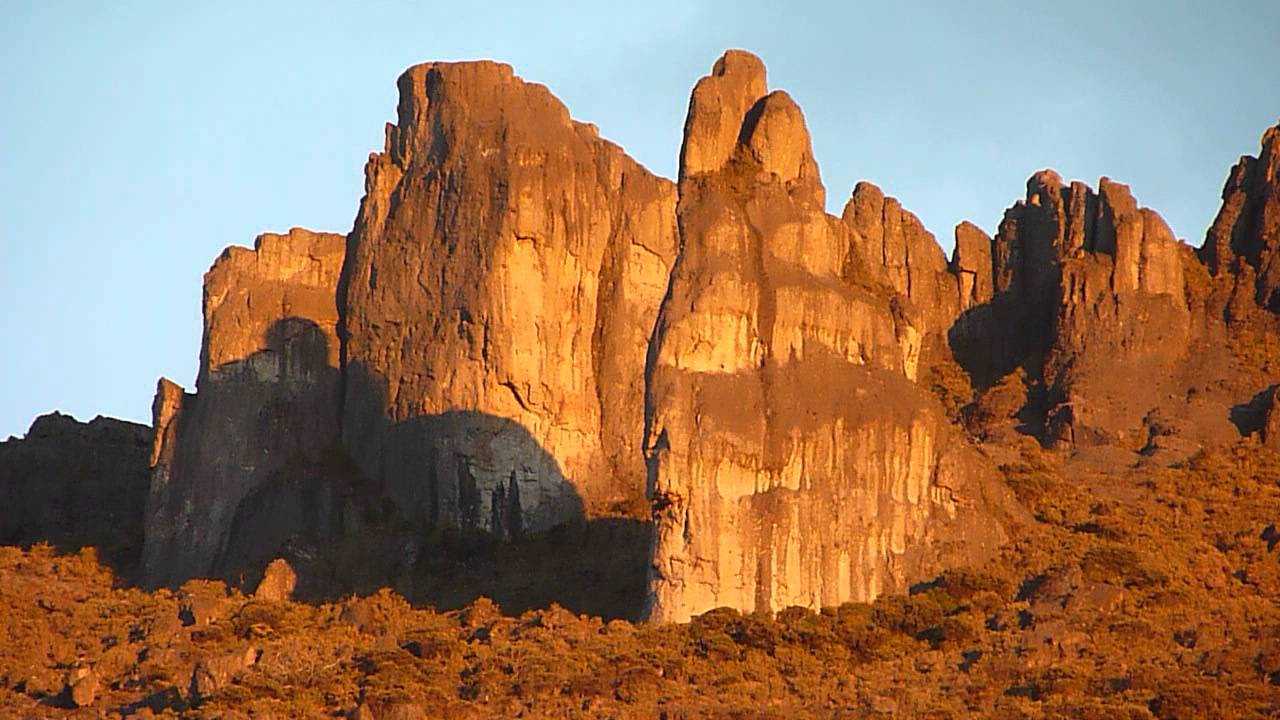
The ACLAP It is found almost entirely in the Talamanca Mountain Range, whose mountain system is the longest in the country, with 320 km in length, 28.9% of it, is intended to protect natural resources. It has extensive areas at sea level and also the highest peaks in the country such as Cerro Chirripó and the Hill of Death.
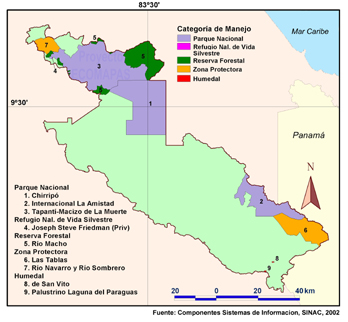
He ACLAP It is divided into several National Parks, Wilderness Refuges and Nature Reservesto say:
- Chirripó National Park 50,920 ha
- La Amistad International Park (PILA, in the Costa Rican sector.) 24,267 ha
- Tapantí National Park – Death Massif 58,495 ha
- Joseph Steve Friedman Wildlife Refuge (Private) 21 ha
- Río Macho Forest Reserve 22,603 ha
- San Vito Wetland 45 ha
- Palustrino Laguna del Paraguas Wetland 51 ha
- Las Tablas Protective Zone 19,926 ha
- Navarro River and Sombrero River Protective Zone 6,465 ha
It is necessary to clarify that the difference between National Park , Wildlife Refuge , Wetland and Protective Zone is located in how that area is managed or administered.
Most of the area of ACLAP It is an unprotected area, which can be exploited for human use as you can see on the map above, green part.
Its hydroelectric production provides drinking water to the Central Valley in its entirety.
In it ACLAP There are two natural world heritage sites declared by the UNESCO, what are they The Crestones and the La Amistad International Park,which only a small part is found within the ACLAP.
Climate of ACLAP
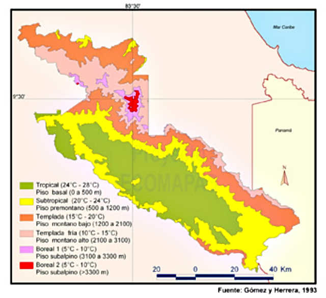
4In this extensive area, the climate is varied, finding areas where the average annual temperature is around 5°C (top of the Cerro Chirripó) and in others 25°C, the average annual precipitation reaches values below the 2000 mm (in the southwest of the ACLAP), while in other areas it even exceeds 5000 mm as in the Tapantí-Macizo de la Muerte National Park.
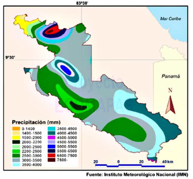
In the entirety of ACLAP coexist 8 different types of climate, to say:
- Subhumid dry, very hot, with a moderate excess of water; for example, in the Térraba River Valley
Average temperature 27°C
Average precipitation 1300-1700 mm - Humid subhumid, very hot, with a very large water deficit, found mainly in the Térraba River basin
Average temperature 21-27°C
Average precipitation 1564-2050 mm - Humid, very hot, with moderate water deficit, as observed in the Térraba River basin
Average temperature 21-27°C
Average precipitation 1900-2400 mm - Humid, very hot, with moderate water deficit, which is noticeable, for example, between Paso Real and Potrero Grande
Average temperature 23-27°C
Average precipitation 2400-2740 mm - Humid, very hot, with moderate water deficit, characteristic of the area around Potrero Grande
Average temperature 23-27°C
Average precipitation 2740-3100 mm - Humid, very hot, with moderate water deficit, observed in the Coto Brus region
Average temperature 23-27°C
Average precipitation 3080-3420 mm - Very humid, from hot to temperate to cold, with a small to moderate water deficit, which occurs in the average and high areas of the Talamanca Mountain Range, especially in the Tapantí – Macizo de la Muerte National Park, the Chirripó National Park and the Las Tablas Protective Zone, Talamanca Mountain Range:
Average temperature 6-26°C
Average precipitation 1600-6840 mm; dry season, from mid-December to mid-April. - Excessively humid, temperate, without water deficit, on the Atlantic slope, especially in the northern sector of the Tapantí National Park – Macizo de la Muerte and the northeastern sector of the Chirripó National Park
Average temperature 12-15°C
Average precipitation 4560-8000 mm; no dry season: it rains all year round.
The Flora and Fauna of ACLAP
There are many types of animals in the area, in total 215 species of mammals, 560 species of birds, 250 species of amphibians and reptiles, and 115 species of fish have been counted, but characteristic of the area are sainos, rabbits, coyotes, tapirs, deer, and felines. Possibly, in the ACLAP and particularly in the Chirripó National Park and La Amistad International Park (Costa Rican sector) are found approximately 60% of all the vertebrates and invertebrates of Costa Rica.
In addition, in ACLAP, it is one of the few sites in Central America that has endangered populations such as the ocelot or manigordo, the red monkey, the caucel or ocelot, the jaguar and the tapir.
There are high altitude cloud forests, high altitude savannahs (Sabana de los Leones) and moorlands, more than 30 glacial lakes (Valle de los Lagos, Valle de las Morrenas) and wetlands.
Population in ACLAP
The ACLAP extends over territories ancestrally occupied by indigenous peoples. Today, this population has been reduced and confined to the indigenous reserves, although it continues to be a fundamental element of cultural and ethnic value.
If you want to know more about the ACLAP, we invite you to read this INBio document.
- Recovered from: https://www.minae.go.cr/index.php/es/
- Retrieved from: https://www.uci.ac.cr/Biblioteca/Tesis/PFGBAP31.pdf
- Recovered from: https://www.inbio.ac.cr/estrategia/Informe1/labor_art8_a1.htm
- Retrieved from: https://www.inbio.ac.cr/ecomapas/ACLAP/generalidades.htm