

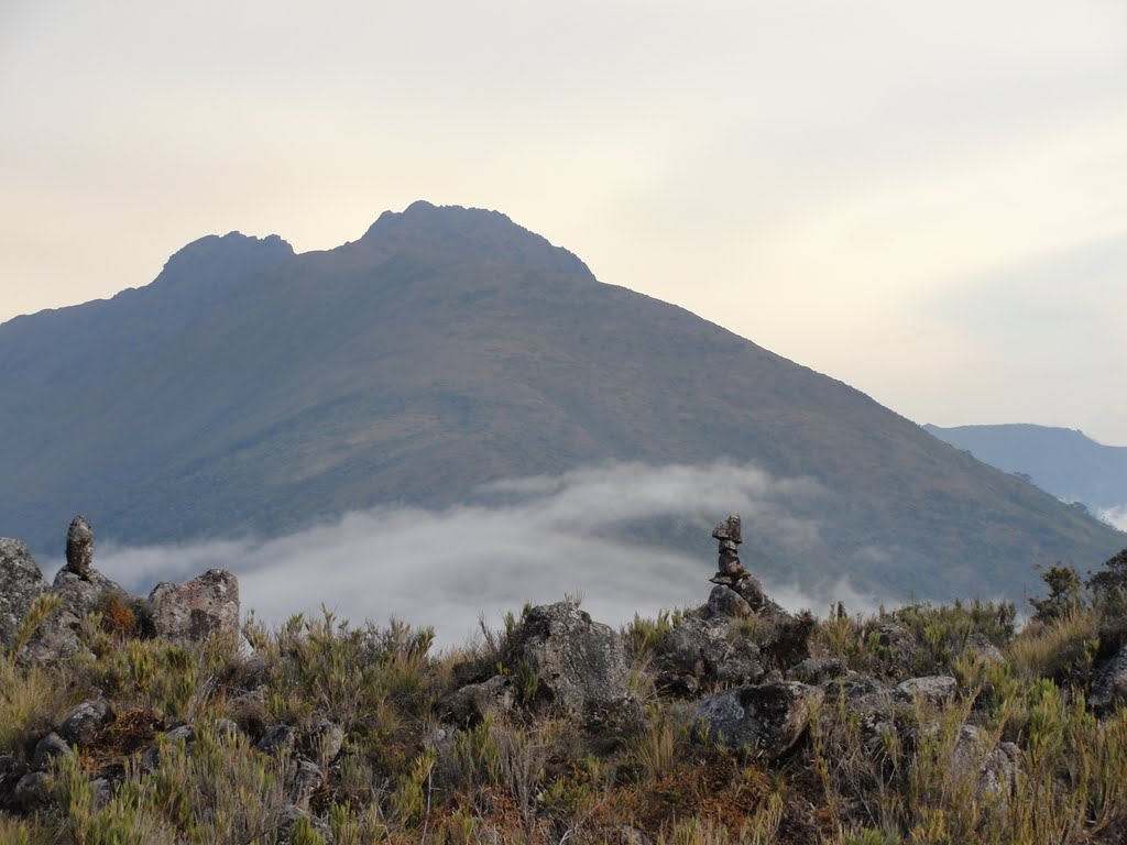
Chirripo National Park was established on July 29, 1975, Law No. 5773 (Gazette Publication No. 165, September 2, 1975, being 40 years old) being located between the provinces of San Jose, Cartago and Limon, 25 km northeast of San Isidro de el General. It is the most famous and beautiful national park in Costa Rica (one of the 7 natural wonders in Costa Rica), not only for its natural attractions but also because there is the highest peak in Costa Rica (the second highest in Central America) and the 38th in the world, called Cerro Chirripo, at 3821 meters above sea level (12530 feet). This beautiful park extends for 50150 hectares, the park each year, captures a good part of the tourism in Costa Rica.
Each year, more than 7000 tourists visit the park, which the indigenous people called “place of the eternal waters” as well as the memories of its majestic beauty once you return home.
Chirripo National Park is located within a much larger area dedicated to the conservation of natural resources and natural beauty called:The Amistad Pacific Conservation Area or ACLA-P, for its acronym, covering this conservation area, most of the Cordillera de Talamanca on its Pacific Ocean side, on this mountain range, are the highest peaks of all Costa Rica.
History of the Chirripó Massif
Approximately 25000 years ago, this entire area was covered by ice sheets of about 2-3 km in extent, which has given rise to the numerous lakes that can be observed, glacial terraces, U-shaped valleys, moraines, all these, part of the landscape produced by a retreating glacier.
Chirripó means: the land of eternal waters, given by the Bribi people (one of the most numerous ethnic groups in Costa Rica), whose settlements are still found in the Talamanca mountain range, which is their spiritual center. The first white man to climb Cerro Chirripo was Father Agustin Bleesing, a missionary from Talamanca, in 1904. Then followed expeditions in 1905, 1914,1915,1920,1932 and 1942.
How to get to Chirripó Park?
We now have two routes to climb Chirripó, one, the well-known traditional route through San Gerardo de Rivas, and the other, recently inaugurated through the town of San Jerónimo.
Chirripo Geography
We must highlight and try to explain some terms before continuing.
In Chirripo National Park is what is known as the “Chirripo Massif” a mountain massif is “a large mountainous mass or a compact group of connected mountains that form an independent portion of land”. Thus, the “Macizo del Chirripo” is formed by 19 hills of more than 3400 meters high and five valleys. All these summits have been denominated and measured in their altitude by the National Geographic Institute. Being a powerful attraction for all those who enjoy mountaineering.
Following is the list of peaks of the “Macizo del Chirripo” in the Cordillera de Talamanca, from southeast to northwest:
Cerro Amó 3400 meters above sea level 9.26 -83.29
Cerro Crestón 3721 meters above sea level
Cerro Terbi 3760 meters above sea level
Cerro Sureste 3733 meters above sea level
Cerro Páramo 3699 meters above sea level
Cerro Ventisqueros 3812 meters above sea level
Cerro Nuevo 3710 meters above sea level
Cerro Northeast 3744 meters above sea level
Cerro Pirámide 3807 meters above sea level
Cerro Chirripó 3820 meters above sea level
Cerro Truncado 3680 meters above sea level
Cerro Lagunas 3761 meters above sea level
Cerro Segundo 3755 meters above sea level
Peak 33 or Cerro Weyl 3635 meters above sea level
Peak 32 or Cerro Weber 3628 meters above sea level
Peak 34 or Cerro Sandner or North Row with 3605 meters above sea level
Cerro Nudo 3762 meters above sea level
Cerro Cúpula 3698 meters above sea level
Cerro Uran 3664 meters above sea level
Note here that a Cerro or Hill is an eminence of the terrain that, in general, does not exceed 100 meters from the base to the top. However, in some countries of South America, Mexico and Central America, as in the case of Costa Rica, some peaks that even exceed 3000 m of altitude are named as hills.
Unfortunately for the visitor, there are only 4 hills that can be visited, according to the park staff, possibly in the future there will be trails to other hills.
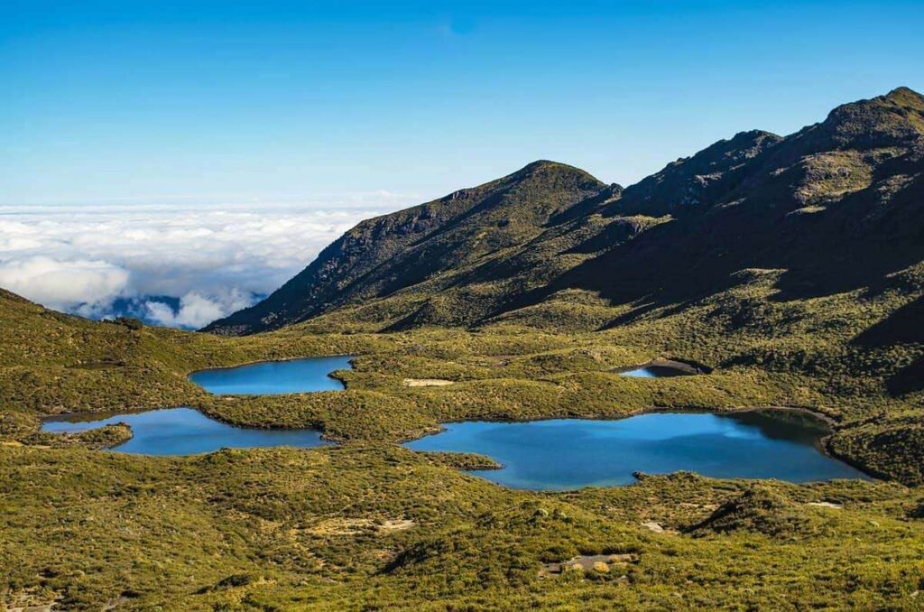
The lakes of Chirripó National Park
There are two valleys containing several lakes called the Valle de los lagos and the Valle de las Morenas respectively, and a solitary lagoon called Laguna Ditkevi containing between them more than 30 lakes between large and small.
The Valleys of Chirripó National Park.
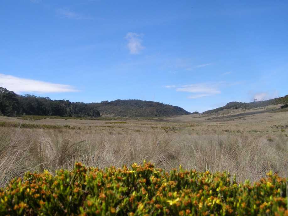
There are 5 valleys in the park, besides the Valle de los Lagos and Valle de las Morenas, there is La Sabana de los Leones, El Valle de los Conejos and a hidden valley that is not accessible to visitors, called El Valle Ancho.
Mount Chirripó is the most prominent peak in Costa Rica, and number 38 in the world! According to the Holdridge Life Zone Classification System, (which classifies a geographic zone according to its climate) the park can be classified into five ecosystems: lowland tropical rainforest, premontane tropical rainforest, low montane rainforest, montane rainforest and subalpine rainforest (páramo). Most of the park is composed of two types of forests, primary rainforest and primary cloud forest. At around 2740 meters (9000 feet) elevation, they become a humid desert.
The park protects the upper basin of the Chirripó Pacífico River, a tributary of the Grande de Térraba River, as well as the upper basin of the Chirripó Atlántico River, the main tributary of the Matina River.
Chirripó Climate
Two seasons dominate Chirripó National Park, the dry season, which runs from December to April, and the rainy season, from May to November, with an average annual rainfall of 3500 mm.
During the dry season, there are frequent fires in the higher parts of the park, the last fires inChirripó National Park were in 1953, 1958, 1976, 1977, 1977, 1981, 1992 (the biggest one that made the park closed for months) and the last one in 2011. Two of these fires have been caused by poachers, the forests of Chirripo are still recovering, which can still be observed on the way to Base Crestones, you will find burned logs from many years ago on your way.
The highest parts of the park, Cerro Chirripo, Monte Uran, Cerro Terbi, Cerro Ventisqueros, are subject to strong winds, frost and frequent drizzle making this park the coldest place in Costa Rica, the lowest temperatures in the history of the country have been recorded inside its gates: -9°C (15°F). To give you an idea of how cold it can get, in the northern hemisphere, temperatures can drop to -5°C (-4°F).
Flora and Fauna of Chirripó
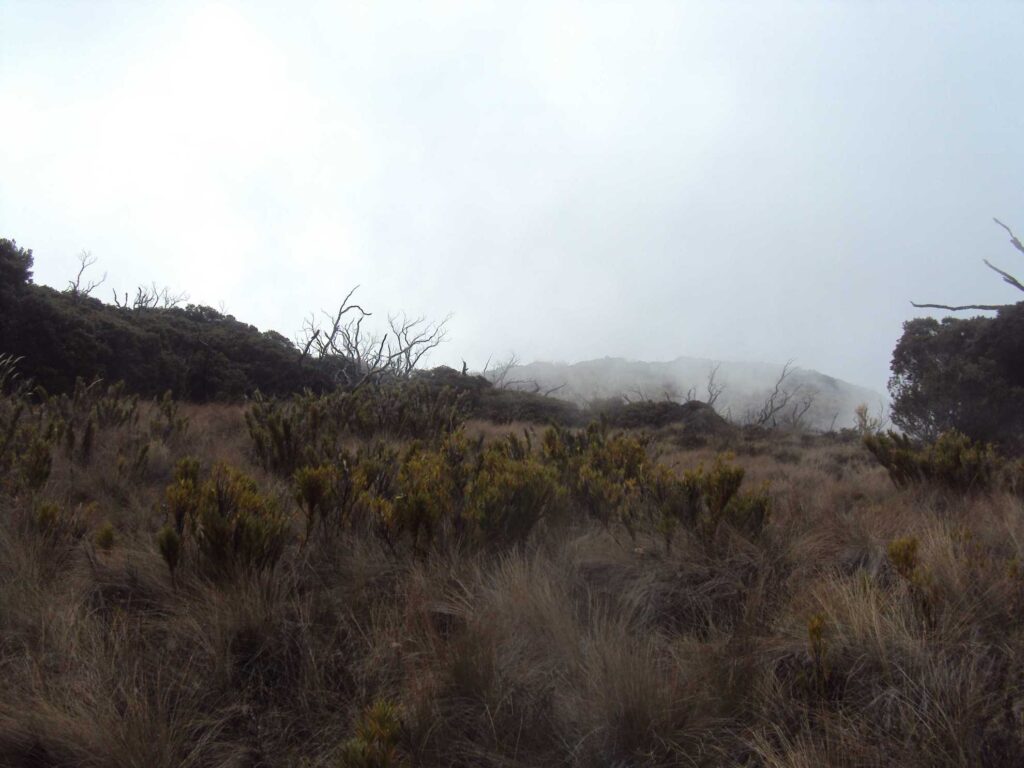
In the upper part of the park the páramo predominates, it has a treeless area of about 60KM approximately.
Multitude of species inhabit the park among them the most outstanding are the squirrels, tapirs (you will be lucky in the Laguna Ditkevi) pumas and jaguars (these can cross you in the early morning on the way to the refuge Base Crestones), rabbits (in Valle de los Conejos), salamanders, frogs, coyotes, toads and the zaínos, salamanders, frogs, coyotes, toads and toads, as well as a great variety of birds such as nuthatches, goldfinches, warblers, hummingbirds, mosquitoes, and the quetzal, a bird that feeds on a type of Lauracea called ira or aguacatillo, worms, insects, reptiles and small amphibians.
Beyond 3400 meters above sea level the páramo dominates, where the vegetation is predominantly scrub (shrubs) with trees no taller than 4 meters, in Central America, only Costa Rica and Panama you can find this type of area. The most common species are the chusquea or cañuela Batamba.
We also find the cloud forest, rain forest and cold forest, oak and oak trees up to 50 meters high characterize this area of life, sow green, leathery leaves, stunted crown and acorns as fruit. The most common oak is the quercus costarricensis.
The cloud forest is characterized by a high content of tree ferns, mosses, bromeliads, palms and orchids, distributed in different strata of the forest.
The importance of Chirripó National Park
The park is a symbol in Costa Rica for eco-tourism and protects the watersheds, with its many streams and springs, providing security to the inhabitants of the surrounding towns, providing high quality water for domestic, agricultural, recreational and hydroelectric use.
Main Attractions of Chirripo National Park
In the upper part of the park there are several areas of great geological, biological importance and great scenic beauty:
Los Crestones:
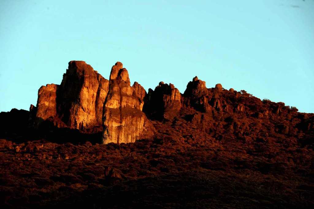
Location: 1.5km from the Crestones Base Lodge Geomorphic rocks.6
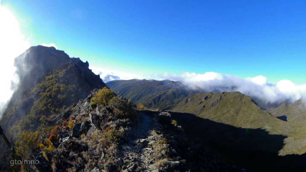
Characteristic site of Chirripo Park, ideal for climbing, this gigantic stone can be seen even about 7km before reaching Base Crestones, in the afternoons, the sun illuminates the Crestones giving them a unique golden color.
Cerro Terbi:
Location: 1.7km from the Crestones base hostel.
Geomorphic rocks. This hill can be visited after passing through Los Crestones, or on the way to Los Crestones, it has an incredible rock path that is fantastic to travel on.
Valle de los Conejos:
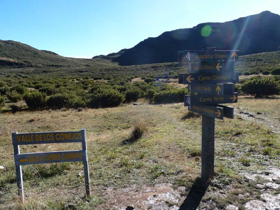
Location: 2.5km north of the Crestones base hostel.
It is a glacial cirque, where the Talari River has its origin. In this place the first shelter of the Park was built in the year 1965. It is the halfway point to several attractions in the park. Originally, there were rabbits in it, little by little they have disappeared and now none are seen. It has a small kiosk where you can rest on your way to either Cerro Chirripo, Ditkevi lagoon, Cerro Terbi or towards Base Crestones.
Laguna Ditkevi:
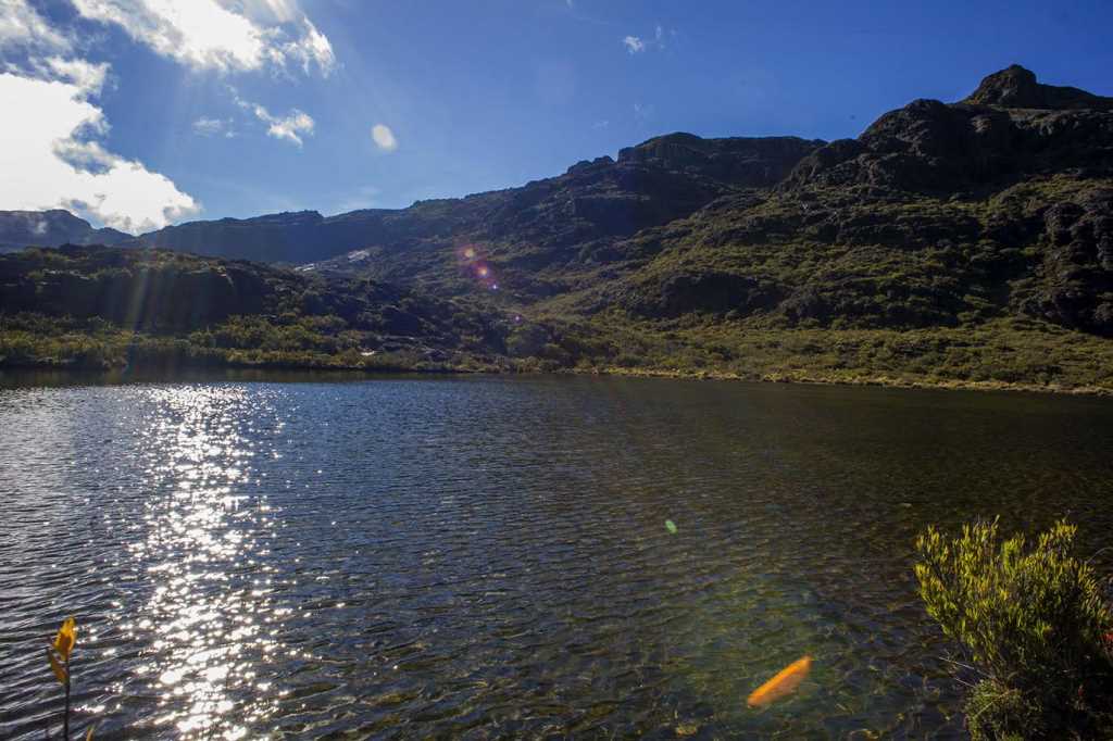
Location: 3km north of the Crestones base hostel.
Glacial origin, with a depth of 8 to 12 meters. You will love its icy waters.
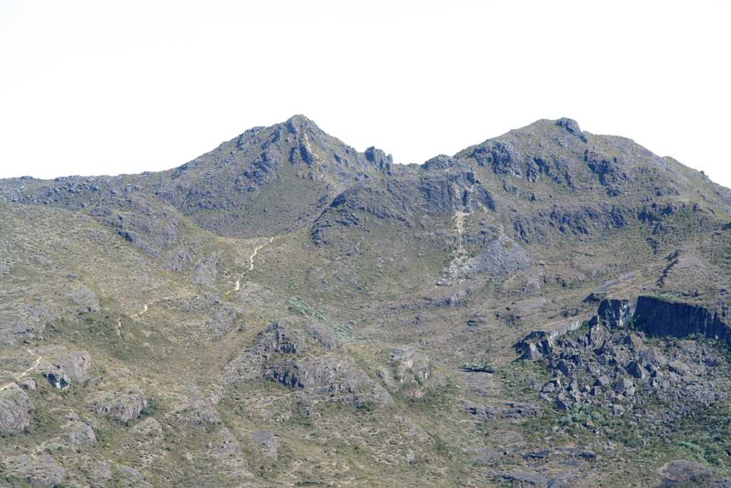
Cerro Chirripó:

Location: 5.5km north of Crestones base lodge.
Highest point in the country and second highest in Central America – 3820 masl. Panoramic view; being clear you can see the Pacific Ocean and the Caribbean Sea. You can also see from its summit, Mount Terbi, Mount Urán, the Morrenas, the Chirripo Lagoon, the Poás, the Barva, and several of the highest peaks in Panama. Rock of volcanic origin.
Cerro Urán:
Location: 7.5km east of Cerro Chirripo.
It has restricted access, only with a guide you can access its summit, since you must access it from Cerro Chirripo.
Cerro Ventisqueros:
Location: 3.1km west of the Crestones base hostel.
Best panoramic view of the entire Park. Strong characteristic winds that give rise to its name, the journey to reach its summit is spectacular. Closeness to the forest.
Sabana de los Leones:
Location: 4km east of the Crestones base hostel.
High altitude valley with the presence of different types of vegetation. On the trail there are excellent viewpoints of the General Valley.
The Sabana de los Leones can be seen even about 7km before reaching Base Crestones.
Valle de las Morrenas:
Location: 7km north of the Crestones base hostel.
Lagoons of glacial origin that drain their waters through the Atlantic Chirripó River. Completely covered by moor vegetation. You can see the remains of the hostel built in the year 1975.
Valle de los Lagos:
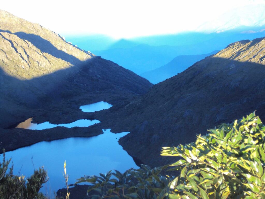
Location: 5.3 km north of the Crestones base hostel 3 lakes of glacial origin.
lake with 22 meters deep and which gives rise to the Pacific Chirripó River.
The Paramo:
Location: At elevations higher than 3000 masl
Ecosystem dominated by grasses, with an extension of 6,000 hectares, with temperatures that can drop to 9ºc. There is high endemism in flora and fauna species.
Crestones Base Shelter
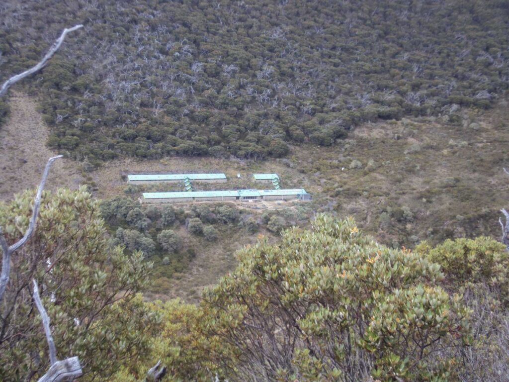
Crestones Base Shelter has numerous rooms with two cabins each, capacity for 4 people, bathrooms (very cold water), food (you can pay for it or not, and bring your own food). Horse rental to transport luggage to the Crestones refuge (muleteer service) Internet (two computers), dining room. At the Base Crestones shelter there is a phone signal, so you can use your cell phone without a problem.
- Recovered from: https://es.wikipedia.org/wiki/Parque_nacional_Chirrip%C3%B3
- Recovered from: https://www.sinac.go.cr/AC/ACLAP/Paginas/default.aspx
- Recovered from: https://es.wikipedia.org/wiki/Sistema_de_clasificaci%C3%B3n_de_zonas_de_vida_de_Holdridge
- Recovered from: https://ecosistemasdecostarica.blogspot.com/2011/07/bosque-tropical-humedo-premontano.html
- Recovered from: https://www.perezzeledon.net/celebran-30-anos-del-parque-nacional-chirripo/
- Recovered from: https://www.parquenacionalchirripo.com/
- Recovered from: https://www.sinac.go.cr/AC/ASP/Paginas/default.aspx